
Buffalo River
- Overview
- Geophysical
- Hydrology and Geohydrology
- Ecology
- Climate
- Land-use
- Populated Places
- Water Infrastructure
- References
Overview
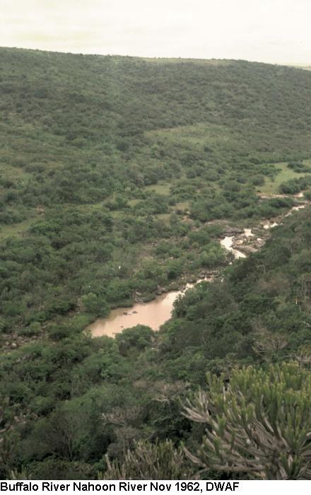
“The Buffalo River has its source in the seeps and sponges of the Amatola Mountains at an altitude of 1200 m. The river is 126 kilometres long and drains a catchment of 1287 square kilometres. From its source, the river descends through indigenous forest in a deeply-incised channel, flanked by rock cliffs up to 120 metres high.”
“Rising at an altitude of 1 200 m, the Buffalo River drains the forested Amatole Mountains of the Eastern Cape . It flows eastwards across the coastal plateau before entering the Indian Ocean at East London harbour. The river is 126 km long. The catchment supports about 570 000 people within its 1 287 km2 area, so population pressure on surface water resources is very high. Less than 500 m3 of water is available per person per annum, among the lowest in the country.”
Tributaries
| Name | Comment |
|---|---|
| Cwengcwe River | |
| Izele River | |
| Mgqakwebe River | The Mgqakwebe tributary is a meandering river with an average width of 4 metres. Trees and shrubs dominate the marginal vegetation. Cobbles and pebbles occur in long stretches of riffle. The pools are shallow. |
| Ngqokweni River | Ngqokweni River, joining the Buffalo River downstream of the Mgqakwebe River, has an average width of 10 to 15 metres. Bedrock and boulders occur with small patches of riffle, and the pools are deep. |
| Yellowwoods River | Cobbles, gravel and sand dominate the upstream and middle section of the Yellowwoods River, while mainly bedrock and boulders with small riffle areas occur downstream. Pools are shallow. |
Geophysical
Topography
The area can be divided into the following three basic topographical zones:
- The Coastal Belt
- The coastal plateau and
- The mountain highlands or escarpment zone
The coastal belt, which is about 10 km wide, and the coastal plateau which rises to between 600 and 900 masl and covers most of the sub-area, are characterized by incised river valleys which run parallel to each other in a south easterly direction. This topography impacts significantly on settlement patterns and the cost of provision of infrastructure within the area. The escarpment zone, which lies between the coastal plateau and the catchment divide is characterized by steep slopes and high altitudes in the upper Buffalo catchment.
Geology
“Rocky outcrops of the catchment consist of sedimentary rocks with dolerite outcrops. The sedimentary rocks consist of mudstones, shales and sandstones that produce highly erodible grey sandy loam soils. The dolerite outcrops weather to form red dolerite and black dolerite clays that are less prone to erosion.”
Soils
“Reduced vegetation cover in large parts of the catchment exacerbates the medium to high natural erodability of the soil.
The riparian zone is the area along a river bank. The four main wetland types in the Buffalo River riparian zone are seep, floodplain, marsh and pan.
Soils are generally moderate to deep clayey loams with alluvial soils in the river valleys.
Hydrology and Geohydrology
Hydrology
“Evaporation rates are 160-170 mm per month in December and January, reducing to 70 mm during June and July.”
The natural mean annual run-off (MAR) for the ISP area is 1 586 million m3/a, with the Amatole catchments contributing 559 million m3/a (35%).
The mean annual precipitation (MAP) varies from 500 mm in some of the river valleys to over 1 000 mm in the upper Buffalo River catchment. The mean annual evaporation (MAE) varies from between 1300mm and 1400mm along the coastal belt, increasing in a north westerly direction to between 1400 mm and 1500 mm.
Ecology
Overview
The high nutrient loads cause eutrophication and result in potentially toxic algal blooms in the dam and excessive growth of water hyacinth. High faecal counts also threaten the health of the communities which still rely on the river for drinking water. Industrial effluents were found to be either inadequately treated or not treated at all. Poor water quality poses a serious health risk for rural communities, since many households rely solely on untreated river water for domestic purposes. The pollution of the Buffalo River basin also extends beyond the estuary, affecting marine and coastal water quality. According to the study the non-compliance with marine water quality standards will render coastal waters unfit for recreational and other beneficial users, including the non-attainment of blue flag beach status, which will in turn impact negatively on coastal tourism and related activities.”
Indigenous fish
Giant spotted eel, Longfin eel, Freshwater goby, Chubbyhead barb, Border barb, Estuarine roundherring, River goby, Cape moony, Flathead mullet, Freshwater mullet, Eastern Cape rocky.
Alien Species
Sharptooth catfish, Carp, Moggel Bluegill sunfish, Smallmouth bass,Spotted bass, Largemouth bass, Rainbow trout, Brown Trout.
Vegetation
Indigenous trees such as the forest elder, Cape fig, common yellowwood, Cape chestnut and white stinkwood, form a continuous canopy of evergreen and deciduous trees.
The highest part of the catchment was once covered with natural grassland, but now consists of pine and blue gum plantations. However, areas where black wattles previously invaded the natural grasslands have been cleared and will be replaced with pine forest plantations, which will create jobs and supply wood for the timber industry.”
There are four biomes in the study area:
- alse macchia,
- forest,
- savannah and
- thicket.
The more arid savannah and thicket vegetation separate the afromontane forests on the mountain slopes from the low altitude coastal forest. The arid savannah, which covers the catchment from below the Rooikrantz Dam to Bridle Drift Dam, is dominated by grasslands and thornveld.
Natural vegetation consists mainly of thornveld or sourveld with areas of dense thicket and indigenous forest in the coastal belt, in the river valleys and in the mountain zone. Invasive wattle (black and silver) is found throughout the area with large concentrations in the Upper Buffalo catchment between King William’s Town and Stutterheim. Exotic weeds are also found to be invading all riparian zone vegetation on an increasing scale.
Indigenous forest covers 7 % of the total catchment area, while pine and blue gum plantations account for a further 4 %. Pirie Forest, in the upper catchment, is the home of a closed canopy indigenous forest.
Evelyn Valley Forest, to the west of Pirie forest, is not formally conserved and includes indigenous forest (about2 000 ha) as well as plantations.
Many species are used for muti and traditional rites, for example, umthathi (sneezewood) and umnquma (forest olive).
The Working for Water Programme is clearing invasive black wattles, on the border of the remaining indigenous forests to restore the grasslands. Forest trees are used for firewood and structural timber.
A large proportion of the Buffalo catchment has been transformed from its natural condition. Almost 17 % of the total catchment area is considered to be degraded thicket and grassland.
Climate
The climate is moderate for most of the year, but with hot, humid periods from December to February. Although the area does receive rainfall throughout the year, it is primarily a summer rainfall region, with the months of June and July being the driest.
Temperature
The climate is warm and temperate. Temperatures are moderate in the coastal zone (8 – 39 °C) with a warm mean annual value of 21 °C. Inland temperatures vary between -2 and 42 °C with a mean annual value of 18 °C
Rainfall
The mainly summer rainfall in the Buffalo River catchment ranges from 400 to more than 1000 mm per year with an annual mean value of about 700 mm.
The coastal grassland, coastal forest and afromontane forest receive the highest rainfall.
Land-use
Agricultural
Agriculture is widespread in the middle reaches of the catchment, from the foothill zone downstream of Rooikrantz Dam to King William’s Town and as far downstream as Bridle Drift Dam.
Goat, cattle and sheep farming is popular in the area.
Local areas of intensive irrigation (less than 1 % of the catchment area) provide fresh produce and other crops such as lucerne.
Nature Conservation, Reserves and Tourism
About 560 ha of natural forest is conserved in the Umtiza Coastal Nature Reserve.
Industries
Industries in the area consist of:
- Motor manufacturing (Daimler-Chrysler)
- Textiles (Da Gama)
- Tanneries
- Toiletries (Johnson & Johnson)
- Pharmaceuticals (Pharmacare)
- Food (Nestlé)
Populated Places
| Town | District | Municipality | River / Tributary |
|---|---|---|---|
| Bisho | Buffalo River | ||
| East London | Buffalo River | ||
| King Williams Town | Buffalo River | ||
| Mdantsane | Buffalo River | ||
| Zwelitsha | Buffalo River |
Water Infrastructure
Dams
| Name | Capacity (mil.cub.m) | Comment |
|---|---|---|
| Bridle Dam | 101 | |
| Laing Dam | 20 | |
| Maden Dam | ||
| Rooikrantz Dam | 5 | Rooikrantz Dam supplies water to King William’s Town and the surrounding areas. |
References:
Department of Water Affairs and Forestry, South Africa. 2004. Mzimvubu to Keiskamma Water Management Area : Amatole – Kei Internal Strategic Perspective. Prepared by FST Consulting Engineers (Pty) Ltd in association with Tlou & Matji and Umvoto Africa, on behalf of the Directorate : National Water Resource Planning. DWAF Report No. P WMA 12/000/00/0404.