
Blyde River
- Overview
- Tributaries
- Geophysical
- Hydrology; Geohydrology
- Ecology
- Climate
- Populated Places
- Water Infrastructure
- References
Overview
The Blyde River is a major contributor to the Olifants River in terms of volume and quality of water. In fact many ecologists feel that if it were not for the Blyde River little or no water would reach Mozambique via the Olifants River in times of drought. The Blyde River is classified as one of the few ‘A’ rivers in the country, which means that it is close to a ‘pristine’ river. It also contributes 65% of the fish diversity in the Biosphere Reserve.
The Blyde River meanders through the Drakensberg and enters the Lowveld before its confluence with the Olifants River. The riverbed is characterized by an abundance of big rocks, stones and pebbles. The riparian zone alternates between narrow zones close to the stream and broad zones with sandbanks and floodplains. The floodplains are elevated in relation to the riverbed. The Blyde River is classified as one of the few ‘A’ rivers in the country, which means that it is considered to be close to a ‘pristine’ river. It also contributes 65% of the fish diversity in the Biosphere Reserve.
Tributaries
| Name | Comment |
|---|---|
| Lisbon River | |
| Rietspruit | |
| Ohrigstad River | |
| Treur River |
Geophysical
Topography
Geology
The geological characteristics of the Blyde catchment consist of a relatively complex series of lithological formations that underlie the area forming the Drakensberg Mountains. In the eastern portion of the upper reaches of the catchment, the most important features are the deep layers of dolomites of the Chuniespoort Formation, interspersed with alternating layers of indurated shales and quartzites of the Pretoria Series of the Transvaal Sequence. In the western portion of this zone, the sub-catchment is underlain by complex sequences of shales, conglomerates, silicified sandstones and quartzites of the Transvaal Sequence. The hard, erosion-resistant rocks forming the northward continuation of the Drakensberg Mountains rise steeply from the Mpumalanga Lowveld, forming conspicuous, steep-sided cliffs.
Water moving through the deep layers of Chuniespoort dolomites in the upper parts of the sub-catchment becomes saturated with calcium carbonate; this precipitates out to form tufa when the water appears above ground level. As a consequence, most of the waterfalls in the area are layered with thick, “growing” deposits of tufa.
In the northern parts of the sub-catchment, downstream of the Blydepoort Dam, crystalline gneissic and granitic rocks of the Basement Complex underlie the catchment. These coarse- to fine-grained, feldspar-rich rocks have been intruded by numerous hard, fine-grained syenite “plugs” that are more erosion-resistant; these are visible as stack-like features across the otherwise undulating terrain in the lower parts of the sub-catchment. In addition to the intrusive syenite formations, the basement complex has also been intruded by a large number of dolerite dykes. These dolerites are softer and more easily eroded than the Basement Complex rocks and the dykes are often visible as troughs in the landscape. These troughs collect rainfall and act as local watercourses; this water enhances the erosion process.
Soils
The riverbed is characterized by an abundance of big rocks, stones and pebbles. The riparian zone alternates between narrow zones close to the stream and broad zones with sandbanks and floodplains. The floodplains are elevated in relation to the riverbed.
Soils in the sub-catchment can be divided into four main groups:
- Moderate to deep sandy and clay-loam soils on flat, gently-sloping and undulating terrain overlying dolomite, limestone and sandstones in the upper reaches of the catchment;
- Moderate to deep sandy to clay loam soils lining long stretches of the Blyde and Ohrigstad river valleys in their middle reaches;
- Moderate to deep clay loam soils over much of the middle portions of the sub-catchment (located away from the river channels), overlying the more porous unconsolidated sedimentary and hillwash material; and
- Moderately shallow to moderately deep, coarse-grained sandy loam to clay-rich, fine-grained soils derived from granites and gneisses over most of the lower reaches of the sub-catchment.
Most of the clayey loam soils are very suitable for irrigated agriculture when sufficient water is provided. Virtually all of the suitable soils are contained within the jurisdiction of formal irrigation boards or Government Water Control Areas. Further away from the main river channels, most of the land use is given over to small-scale irrigation from farm dams as well as the raising of small and large livestock (dairy and beef cattle, goats and sheep). A wide variety of crops are produced, ranging from intensive vegetable production to tobacco, maize, citrus and sub-tropical fruits, sorghum and sunflowers. Minor areas of plantation forestry (mostly Pines and Eucalyptus) are also located in the wetter portions of the sub-catchment.
Hydrology and Geohydrology
Hydrology
The Blyde River catchment has a high rainfall and the water emanating from the Blyde River makes an important contribution to the base flows in the lower reaches of the Olifants River passing through the Kruger National Park.
This sub-catchment consists of the area drained by the Blyde River and its main tributary, the Ohrigstad River . Both the Blyde and Ohrigstad rivers rise on the western slopes of the north-south trending Drakensberg Mountains and flow northwards towards the escarpment edge where they join at the Blydepoort Dam, which is located at the edge of the escarpment. From the Blydepoort dam, the Blyde River cascades down a steep series of rapids to its lower reaches, where the river again flows northwards to join the Olifants River north of the town of Hoedspruit . Ground water from the Chuniespoort dolomites provides an important component of the water in the Blyde River .
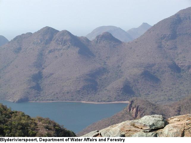
The Blydepoort Dam is the largest impoundment on the Blyde River and regulates flows in the lower reaches. Several small farm dams in the upper reaches of the Blyde and Ohrigstad rivers trap water for domestic purposes and for limited areas of commercial irrigation, as well as livestock watering. The small Ohrigstad Dam provides water for the town of Ohrigstad.
Flow patterns in the upper reaches of the Blyde and Ohrigstad rivers are relatively stable as these rivers drain an area that receives some of the highest rainfalls recorded in South Africa (average rainfalls in the headwater regions of these two rivers exceeds 1,500 mm per year). Both rivers are therefore perennial, though flows increase during the summer months when rain is received. Smaller tributary streams in the upper reaches are also perennial, though their flows are more variable. In its lower reaches, the Blyde River receives small quantities of water from several episodic tributary streams that only contain water during the summer months.
Ecology
Overview
The Blyde River gorge has been cleared of alien species like wattles and pines, and water from the Blyde River generally improves the water quality in the Olifants River downstream of their confluence.
Aquatic Animals
Fish: Treur River Barb, The Natal Mountain Catfish
This Blyde River section which exclusively contains the Lowveld Riparian Forest is also an important refuge area for several fish species and several other animals which have largely disappeared from the Olifants River due to loss of habitat.
Terrestrial Animals
There are mountain reedbuck on the escarpment, dassies on the canyon walls, hippo and crocodile in the Blyde Dam, and impala, kudu, blue wildebeest, waterbuck and zebra on the Lowveld plain near the canyon’s mouth.
Vegetation
The riparian forest along the Blyde River, above its confluence with the Olifants River, is probably the most extensive natural riparian forest of its kind in South Africa and is of considerable conservation value.
This riparian forest is classified as Lowveld Riparian Forest and forms part of one of the smallest forest types within South Africa. Comparable riparian forests over much of its distribution within the eastern half of S outh Africa are mostly fragmented or transformed by alien plantation.
The forest along the Blyde River is extensively developed within the last few kilometres above its confluence with the Olifants River. This fragile area is only around 100 Hectares in extent. The Lowveld Riparian Forest creates an important habitat and refuge for specialised fauna and flora such as the Vulnerable Pel’s Fishing Owl whose habitat in South Africa is dwindling rapidly.
Climate
Temperature
The climate varies from cool in the Highveld region to sub-tropical east of the escarpment.
Rainfall
The mean annual rainfall falls in the range 500 mm in the Lowveld region, reaching 1000 mm in the mountains.
Populated Places
| Town | District | Municipalities | River/Tributaries |
|---|---|---|---|
| Bergpunt | Mpumalanga | Orighstad River | |
| Chester | Limpopo | Blyde River | |
| GaMaraba | Mpumalanga | Orighstad River | |
| Graskop | Mpumalanga | Blyde River | |
| Klipfontein | Limpopo | Orighstad River | |
| Moremela | Mpumalanga | Blyde River | |
| Orighstad | Mpumalanga | Blyde River | |
| Pilgrims Rest | Mpumalanga | Blyde River | |
| Rietfontein | Limpopo | Orighstad River | |
| Richmond | Limpopo | Blyde River |
Water Infrastructure
Dams
| Name | Capacity (mil.cub.m) | Comment |
|---|---|---|
| Blyderivierspoort Dam | 54.4 | Blyde River |
| Orighstad Dam | 14.4 | Orighstad River |
REFERENCES:
Department of Water Affairs and Forestry, South Africa. 2004. Olifants Water Management Area: Internal Strategic Perspective. Prepared by GMKS, Tlou and Matji and WMB on behalf of the Directorate: National Water Resource Planning. DWAF Report No P WMA 04/000/00/0304 .