Crocodile River
- Overview
- Tributaries
- Geophysical
- Hydrology; Geohydrology
- Ecology
- Climate
- Land-uses
- Populated Places
- Water Infrastructure
- Reference
Overview
The Crocodile (West) Marico Water Management Area falls mainly within the North West Province, but it also incorporates sections of the Limpopo and Gauteng provinces.
Upper Crocodile sub-management area corresponds to the catchment of the Crocodile River upstream of the confluence of the Elands River which includes the major tributaries of the Sterkstroom, Magalies, Bloubankspruit, Jukskei and Hennops rivers. The Crocodile River has its source in the Witwatersrand mountain range at a height of 1 700 m.a.s.l. The northern suburbs of Johannesburg, as well as parts of adjacent cities such as Kempton Park and Krugersdorp are situated in this sub-catchment. There are two large dams in this sub-catchment, namely Hartbeespoort and Roodekopjes. The upper reaches of the catchment are densely settled.
Tributaries
| Name | Comment |
|---|---|
| Bloubankspruit | |
| Hennops River | |
| Jukskei River | |
| Magalies River | |
| Sterkstroom River |
Geophysical
Topography
The Crocodile River is a major tributary of the Limpopo River which discharges into the Indian Ocean in Mozambique. The Pienaars, Apies, Moretele, Hennops, Jukskei, Magalies and Elands river are the major tributaries of the Crocodile River, which together make up the tertiary hydrological catchment with its 39 quaternary catchments.
The Crocodile River itself does not form any international boundaries but contributes to the flow of the Limpopo River, which has an international river basin shared with Botswana, Zimbabwe and Mozambique. The upper portion of the catchment, south east of Hartbeespoort Dam, is located in the Gauteng Province. The north and north east corners lie in the Limpopo Province whereas the central or western sections fall within the North West Province.
Geology
The major geological feature of this catchment is the large area of volcanic intrusive rock (north of the Magaliesburg to Thabazimbi) referred to as the Bushveld Igneous Complex. Formations in this complex are extremely rich in minerals, which has led to large-scale exploitation of the platina group of metals in this area. Soil types in this area may be broadly classified as moderate to deep clayey loams which are well utilised for agricultural crops and which also allow a relatively high percentage of runoff of water.
Hydrology and Geohydrology
Hydrology
The natural mean annual runoff (MAR) of the Crocodile (West) Marico water management area is 855 million m3/annum. Approximately 75 % of the total surface runoff from the Water Management Area flows down the Crocodile River, while the Marico catchment contributes 20 % and the Upper Molopo catchment 5 %.
More than half of the total water use in the water management area comprises urban, industrial and mining use, approximately a third is used by irrigation and the remainder of the water requirements are for rural water supplies and power generation. These water requirements are far more than what can be provided by the current water resources. In order to meet the current demand, much of the water in the water management area is being imported mainly from the Vaal River system for domestic and industrial use purposes. Rand Water, which is the largest water board in South Africa, together with Magalies Water and Botshelo Water (the North West Water Supply Authority), are the three water boards that supply water in this water management area.
Ecology
Overview
The Crocodile River and some of its main tributaries rise in the south of the catchment in the Witwatersrand topographical feature. This feature in the southern part of the catchment may be described as gently rolling hills on the highveld plateau. The Crocodile River then meanders through a reasonably flat weathered volcanic landscape, past the extinct Pilansberg volcano, and through the Thabazimbi mountains down to its confluence with the Groot Marico where it becomes the Limpopo River.
Aquatic Animals
Aquatic weeds such as water hyacinth Eichhornia crassipes and toxic blue green algae Microcystis aeruginosa have in the past, and still do, cause serious problems in the Hartbeespoort Dam. The aquatic riverine environment has been significantly modified by developmental pressure on the river system. Only a few indigenous fish species still remain, with exotic fish species dominating these watercourses. More needs to be learned regarding the status of these indigenous fish species in this catchment.
Terrestrial Animals
The environment in the more densely settled rural areas in the southern portion of the Crocodile River Catchment still contains populations of small game and their predators, reptiles and a wealth of bird species. The Magaliesberg Mountain Range and the more rural areas further to the north still have medium and large sized game. Game farms to the north form some sort of sanctuary to these animal populations.
Vegetation
There are two main types of natural vegetation in the Crocodile River catchment (Acocks classification system):
- False grassland, in the portion of the catchment south of the Magaliesberg. Vegetation associated with this veld type is sour, wiry grassveld, proteas and acacias.
- Tropical bushveld and savannah, north of the Magaliesberg.
Climate
Temperature
The upper higher lying areas of the catchment experience cold winters and reasonably hot summers. Frost is prevalent in winter. North of the Magaliesberg Mountain Range very little frost occurs and winters are more moderate.
Rainfall
Summer (October to April) rainfall patterns predominate with the traditional heavy deluges in the afternoon (cumulonimbus induced thundershowers being the norm)
December and January are the peak rainfall months with hail being prevalent. Frontal climatic systems bring soft soaking rains on occasion.
Land-use
Agricultural
The upper false grassland areas in the south of the catchment have been significantly modified by urban development and smallholder agricultural activities. Exotic vegetation predominated the banks of the various tributaries until recently. Very active intervention of the national Working for Water Programme and local resident organisations (including the Jukskei River Water Forum) have however begun to eradicate this invasive alien vegetation with the view of rehabilitating greenbelts along these tributaries. Agricultural activities (irrigated and dry-land cropping, cattle and sheep grazing) are widespread in this ecoregion.
Industries
Some of the gold-bearing seams of the Witwatersrand Ridge in the south fall within the upper catchment but only a few goldmines still operate here.
Populated Places
| Town | District | Municipality | River/ Tributary |
|---|---|---|---|
| Bela Bela | Waterberg | Bela Bela | |
| Brits | Bonjanala | Madibeng | |
| Kempton Park | City of Johannesburg | City of Johannesburg | |
| Krugersdorp | West Rand | Mogale City | |
| Johannesburg | City of Johannesburg | City of Johannesburg | |
| Pretoria | City of Tshwane | City of Tshwane | |
| Rustenberg | Bonjanala | Rustenburg | |
| Thabazimbi | Waterberg | Thabazimbi |
Water Infrastructure
Dams
| Name | Capacity (mil.cub.m) | Comment |
|---|---|---|
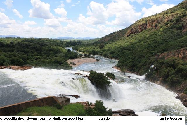
| Hartebeespoort Dam | 186.4 | Crocodile River/Limpopo River Arch Dam |
| Rietvlei Dam | 12.3 | Crocodile River/Marico River/Limpopo River |
| Roodekoppies Dam | 102.3 | Limpopo River |
| Roodeplaat Dam | 41.2 | Pienaars River/Crocodile River/Limpopo River |
| Klipvoor Dam | 42.1 | Moretele River/Crocodile River/Marico River/Limpopo River |
| Olifantsnek Dam | 14 | Elands River/Crocodile River/Marico River/Limpopo River |
| Bospoort Dam | 16 | Hex River/Elands River/Crocodile River/Marico River/Limpopo River |
| Lindleyspoort Dam | 14.3 | Elands River/Crocodile River/Marici River/Limpopo River |
| Vaalkop Dam | 56 | Elands River/Crocodile River/Marico River/Limpopo River |
REFERENCES:
Department of Water Affairs and Forestry, South Africa. 2004. Crocodile River (West) and Marico Water Management Area: Internal Strategic Perspective of the Crocodile River (West) catchment.