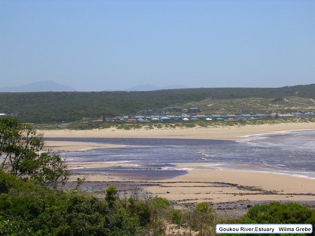
Goukou River Estuary
- General Information and location
- Catchment Characteristics
- Land and Estuary Uses
- Ecology
- Water Quality
- Hydrodynamics and Mouth Dynamics
- Physical features
- Climate
- References
General Information and Location
General
There are few reliable records for the Goukou Estuary prior to 1900 but it appears that the first Europeans to reach it overland were trekboers on the Great Trek in 1730 (Bohnen, 1986). The first map of the estuary and its approaches was that of Dayman (British Admirality), drawn in 1855 and the name Still Bay, indicative of its relative calmness in westerly winds, first appeared on an 1899 map. Farmers from the Riversdale and Klein Karoo regions visited the estuary over the summer months from as early as the late 19th century. Families trekked there by oxwagon and up until 1902 generally camped on the east bank of the estuary in the area called Lappiesbaai. In 1902 the Goukou River came down in flood, washing away most of the vegetation in the Lappiesbaai area. Thereafter the campers moved to “Die Braak” because of the problems with driftsands. The site was used until as late as 1952.
Physical development at Still Bay started on the west bank of the Goukou Estuary with the surveying (in 1873) and auctioning (in 1898) of 12 erven later known as Little England. The construction of an access road to Still Bay West started in 1895, encouraging further subdivision and sale of erven primarily on the farms Platbosch and Jagersbos, and on some State ground. The presence of freshwater springs facilitated development on land to the west of the estuary.
On the east bank physical development was slow, this being due to the scarcity of fresh water and inundation of the low-lying areas during large floods. The 1902 floods damaged the three houses which had been built at Lappiesbaai and although rebuilding started as early as 1904 development o the east bank was slow through to the 1950s.
Subsequent houses which were built at Lappiesbaai were erected on stilts for protection against the high spring tides and floods. Later development on the east bank occurred primarily on the farm Ellensrust and on some State ground.
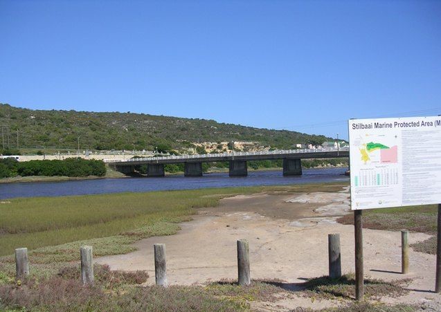
Initially, transport between the east and west bank was by way of flat-bottomed craft (platboomskuite). In 1993 a pontoon began operating across the river about 5 km upstream from the mouth and in 1955 a road bridge constructed upstream of development on both banks, was completed. The access road to Still Bay was tarred in 1965 and the village attained municipal status in 1966.
An interesting, albeit short-lived event in the history of Still Bay was the exploration for, and brief yield of oil on the ‘Rooisandkoppie’ to the north-west of Still Bay West in the early 1920s (Centrespread). This was a precursor of the far more intensive search for oil and gas deposits offshore from Still Bay over the last decade.
Location (co-ordinates)
The mouth of the Goukou River is situated at 34°122’S, 21°25’E, about 30 km south of Riversdale.
Catchment Characteristics
Main Rivers and Tributaries
The catchment area of the Goukou River is given as 1 188km2 by Heydorn and Tinley (1980) while the gross and effective areas of the catchment are given as 1 550 and 1 155km2 respecitively by Pitmand et al. (1981)
Excluding minor streams, there are five major tributaries draining into the Goukou River, namely the Soetmelks, Naroo, Brak, Vet and Kruis rivers.
Dams
There is one large reservoir, the Korente-Vet Dam (Centrespread) on the Vetrivier in the Goukou River catchment. It is situated north-west of Riverdale and has a storage capacity of 9,46 mil.cub.m. and was constructed in the period 1963-1965. This dam supplies the Korente-Vette River Irrigation canals north-east of Riversdale and the town of Riversdale.
River run-off
According to Pitman et al. (1981) the mean annual run-off (MARS) for the Goukou River catchment is 106,42×10⁶m3. Years with run-off greater than 150 x 106m3 (‘big floods’) have an average interval of occurence of 3,2 years and years with run-off exceeding the MAR occur on average every 2,8 years.
There have been a number of floods in the Goukou. The first recorded flood, probably because of its effect on property, was that of 1902 when the traditional campsite on the eastern sandspit at the estuary mouth was washed away and the houses built on the dunes as Lappiesbaai were severely damaged.
Since then, there have been no reported flood incidents of a similar magnitude, although stormy conditions in 1978 prompted home-owners on the east bank of the estuary to build protective walls against flood waters, and in 1981 high flow in the estuary was noted by residents to have flushed out sand at the mouth. The most recent of such events was August 1986 where increased river flow, high local rainfall and high seas led to back flooding in the estuary and inundation of the surrounding low lying areas.
The biggest flood peak on record for the Goukou River, 358 cumecs, was measured on 25 January 1981, having an estimated return period of 20 years (Z. Kovacs, Department Water Affairs, pers. comm). The volume flow of a 100-7ear flood has been estimated at about 1 400 cumecs.
Geomorphology
Geology
The two rivers originate in the 1 000 to 1 700m high Langeberg Mountains of the Cape Fold Belt. These mountains are formed of Table Mountain Sandstone of the mid- Palaezoic Cape Supergroup. From here, the rivers cut through a peneplain plateau of from 100m to 300m which slopes to the coast. The Goukou and Duiwenhoks rivers pass through 10 and 13 km respectively of highly erosive Cretaceous sedimentary rocks of the Enon Formation (particularly clays and conglomerates), followed by roughly 40 and 20 km respectively of Palaeozoic Bokkeveld shales.
The Goukou River opens at the coast in gently sloping surroundings of Tertiary aeolianites (dune rock) and coastal sands, with a few outcrops of the estuary mouth, bed erosion has reached the top of the Bokkeveld shales. Between Vermaaklikheid and the coast, the Duiwenhoks River cuts through some 7 km of calcarenite (limestone containing more than 50 percent calcium carbonate) of the Bredasdorp Formation, overlain by Quaternary sands. In this section of its course the river flows through a 100 to 150m deep canyon-like valley to emerge in a wide but steep-sided basin at the coast.
Land and Estuary uses
Residential
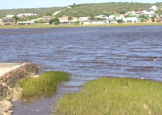
Landuse adjacent to the estuary and in Still Bay is primarily focused on holiday accommodation and recreation and this has a strong seasonal component. An estimated 80 percent of the business sector is directed at these holiday-makers.
The popularity of Still Bay as a holiday resort and place in which to retire has grown steadily over the years.
Agricultural
The major part of both river catchments is made up of privately-owned farms, where mixed farming is practiced. Cultivation of small grain cereals (mainly wheat) and dryland pasture, in combination with wool sheep and dairy cattle farming are the predominant activities. Tobacco is grown on small scale and a few ostriches are kept for their feathers. Bee farming in the dune areas is an important economic activity. Agricultural productivity is generally higher in the middle and upper catchments than near the coast where soils are poorer.
n 1981 approximately 12km2 of the Goukou catchment were afforested with 25,512km2 under irrigation (pitman et al. 1981)
Industrial
An interesting, albeit short-lived event in the history of Still Bay was the exploration for, and brief yield of oil on the ‘Rooisandkoppie’ to the north-west of Still Bay West in the early 1920s (Centrespread). This was a precursor of the far more intensive search for oil and gas deposits offshore from Still Bay over the last decade.
Recreation
There is a privately owned Caravan Park as well as a Municipal campsite and caravan Park.
The Goukou Estuary itself is renowned for its angling and is also used for boating, swimming and sailing. The usual estuarine fish are present and some large Leervis and Kabeljou have been caught over the years. Kabeljou in excess of 45 kg have been landed from the estuary. This is becoming and increasingly rare event (Steyn, 1983). Bait organisms abound in the estuary and bait collection is an integral part of angling.
For boating there are public launching ramps on the east and west banks of the estuary about 2km upstream from the mouth. Apart from jet-skis and jet-propelled craft all boats are permitted on the estuary.
Conservation
There is one game reserve in the upper catchment area, the 320 ha Werner Freshe Reserve which is owned by the Municipality of Riversdale and has just been leased for an eight year period to a game farmer who may also run cattle there.
There are two Nature Reserves in the vicinity of the estuary (Centrespread). The largest is the Geelkranz Reserve which comprises 700ha of dune fynbos and strandveld and is controlled by the SDNEC. The Still Bay Municipality manages the smaller Pauline Bohnen Nature Reserve, which consists of approximately 147,5 ha of limestone fynbos. This reserve was proclaimed in 1982.
Ecology
Flora
Semi-aquatic Vegetation
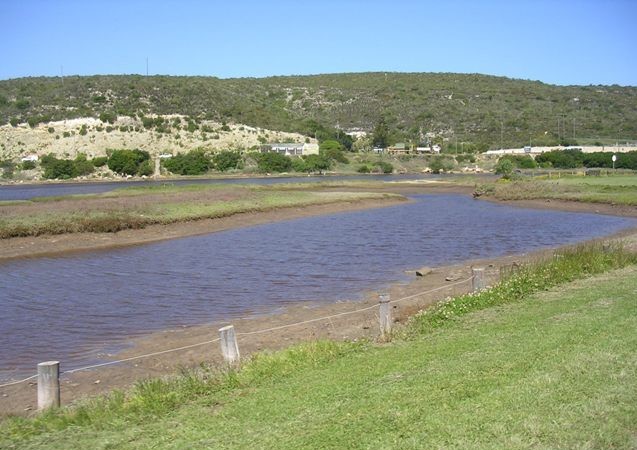
Saltmarshes are found along both banks of this estuary and cover large areas along the eastern bank below the road bridge. Spartina maritima (strandkweek) dominates the lower areas, followed by Sarcocornia perennis, Limonium scabrum and Cotula coronopifolia. Within this middle zone, the annual glasswort Scalicornia meyerana often occurs in disturbed areas. Higher up the shore, Juncus kraussil is found.
Further up the river, where salinities drop to below 15 parts per thousand, patches of Phragmites australis fringe the river. Even higher up the river, occasional stands of Typha capensis are found where there is a fairly constant fresh water supply.
Terrestrial vegetation
The vegetation of the Riversdale Plain, in which the catchment of the Goukou rivers falls, can be divided into three non-fynbos types (forests and thickets, karroid and renoster shrublands and grasslands, and grassy shrublands) and five fynbos types (grassy, asteraceous, restioid, proteoid and ericaceous). The distribution of these types is strongly related to the geology and soil characterisitics of the area.
Dune vegetation: The dune vegetation consists of three types: dune pioneers, dune scrub and dune fynbos. Dune pioneers are found on the foredunes and reach their greatest abundance to the east of the estuary. Species such as Arctotheca populifolia, Agropyron distichum and Tetragonia decumbens are common and Scaevola plumieri occurs but is reaching its westernmost distribution point. Dune scrub appears as small patches of southern coast strandveld on the deep alkaline sands of the dunes on both sides of the estuary. This vegetation type hardly grows taller that two metres and is compromised of fleshy-leaved shrubs but no proteoids nor aloes. Numerous restioids, such as the tall Thamnochortus erectus and the short Ischyrolepsis eleoachris and numerous Ficinia species are found here, toghether with shrubs such as Metalasia muricata, Helichrysum species and Rhus species. Cowling et al. (1988) differentiated Dune asteraceous fynbos fromt he more general asteraceous fynbos type on the basis of the high cover of non-ericaceous ericoids and absence of proteoids. This vegetation type occurs on young calcareous sands and is extremely limited in distribution. There is a small patch on the Still Bay West peninsula (behind Morris Point). (RM Cowling, 1987 in litt).
Riparian thicket: This vegetation is mainly found along the eastern bank of the river on Bokkeveld shales. It contains numerous succulent species such as Aloe arborescens, Euphorbia mauritanica and other species such as Azima tetrachantha, Rhus longispina, Lycium afrum, Euclea racemosa and Sideroxylon inerme.
Upland fynbos: This consists of two types. The Leucadendron meridianum/Protea obtusifolia community is a mesic proteoid fynbos vegetation type which is found on soils up to 0,5m deep on the crests and midslopes of limestone outcrops and ridges to the east and west of the river. The oligotrophic asteraceous fynbos community is found on shallower limestones soils, primarily on the slopes bordering the river valley.
Alien vegetation: Alien shrubs, mainly in the form of the highly invasive Acacia cyclops (rooikrans) dominate large areas, particularly on the dunes. Other alien plants including Solanum nigrum (Black nightshade) and Opuntia ficus-indica (Prickly pear) were also noted in the area.
A large proportion of the Goukou Estuary is either used for agriculture or recreational and residential purposes. This, coupled with the large encroachment of alien vegetation is placing some of the plant communities at risk. The efforts of the local community in the removal of aliens from the proclaimed nature reserves deserve commendation. These efforts should be extended to protect and re-establish areas of natural vegetation. Of particular importance here are the salt marshes, as they are sensitive to both trampling, grazing and wave damage from passing speedboat wakes, and the more restricted fynbos types. A clear case in point here is the dune asteraceous fynbos vegetation type that occurs behind Morris Point.
Fauna:
Zooplankton
Grindley (in litt.) sampled the Goukou estuary in May 1969 and recorded 19 and 12 taxa respectively. Mean zooplankton biomass for this period in the Goukou Estuary was 51,88mg DW/m3 (N=5). The high values observed at the Goukou were due to an extremely high biomass recorded at the estuary mouth (135,3mg DW/m3 ). However, because of the small coverage obtained in time and space it is difficult to draw conclusion on the significance of this value or make comparisons between the two systems and with other South African estuaries.
Aquatic Invertebrates
Of the four bait organisms, blood worms and razor clams are the most sensitive to exploitation. The former species spreads to the more inaccessible subtidal regions of estuaries and therefore the population may be buffered against over exploitation to some extent (Gaigher, 1978). However, other factors also affect this population, eb B de la Bat (pers.comm.) has observed that blood worms suffered a marked decline in the Goukou after the 1981 Laingsburg floods. Recovery has apparently been poor. Razor clams, although widely distributed, are generally ver sparse but as individuals also inhabit subtidal areas, the population is probably buffered against over exploitation.
Fish
Both estuaries support winter migrations of the southern mullet, Liza richardsoni. De la Bat (pers.comm.) states that these migrations can be large. He further states that the mullet form large shoals in the estuaries and whilst migrating upstream ‘make a noise like a 10 ton truck.’ The mullet apparently remain in the systems for three to twently days whereafter they migrate out to sea again.
The coastal regions adjacent to the two estuaries provide good, varied rock angling and limited sandy beach angling. Galjoen (Coracinus capensis) and elf (Pomatomus saltatrix) are seasonally plentiful whilst large kob (Argyrosomus hololepidotus) and musselcracker (Cymatoceps nasutus) are occasionally landed. Angling success is allegedly diminishing and some previously commonly caught species (eg dageraad, Chrysoblephus cristiceps) have virtually disappeared (Steyn, 1983). This phenomenon is unfortunately not limited to this area and is apparently a result of fishing pressure.
Still Bay harbour itself has supported a commercial fishery based on line fishing boats with a major commercial company erecting a coldstore for catches in the early 1960’s, and another currently proposing to do so. Over the years the larger species caught have changed from dageraad (Chrysoblephus cristiceps), roman (Chrysoblephus laticeps), etc. to kabeljou (Argyrosomus hololepidotus). This change has apparently been dictated by availability.
Birds
The Western Cape Water Study Group (Summers et al., 1976) recorded six migrant and three resident wader species at the Goukou Estuary.. Ryan et al. (1988) listed eight migrant and four resident wader species at the Goukou Estuary.
Mammals
Schreiber’s longfingered bat, Temminck’s hairy bat, Cape horseshoe bat, Striped mouse, Cape dune molerat, Cape fox, Striped pole cat, Honey badger, Cape grysbok.
Further to this Bosbok (Tragelaphus scriptus), Dassie (Procavia capensis), Creeping Mole (Amblysomus hottentotus) and Marsh Mongoose (Kommetjiegatmuishond, Atilax paludinosis) have been observed in the area (Rudd, pers.comm.)
Water Quality
Physio-chemical Characteristics
Similar to most Cape south coast estuaries, data on the physical and chemical characterisitics are extremely sparse. The discussion below is based on measurements made during the ECRU surveys of March (summer) and August (winter) 1985.
The temperature and salinity data for both surveys indicate that the classical salt water lens found in estuaries does not exist in the Goukou Estuary. The slight temperature inversion plus salinity gradient found 1,7 km upstream in the winter survey cannot be interpreted as being indicative of such a lens because of the depressed (relative to seawater levels) salinities. The absence of a lens can be attributed to the lack of a sill at the mouth to retain dense water, the low flow rates of the river in general and the tidal domination of the flow in the estuary.
The distribution of pH values, oxygen and phosphates are as to be expected for a southern Cape estuary (Taljaard, 1987). Nitrate-nitrogen concentrations, however, show an inverse relationship with salinity, indicating that the river is the major nitrogen supplier to the estuary. The elevated nitrate-nitrogen concentrations upstream are probably related to agriculture.
The particulate organic matter concentrations found in the water column are moderate whilst the total chlorophyll concentrations are low. Therefore most of the particulate organic matter is probably derived from fringing macrophytes and/or imported marine seaweed. From this it can be inferred that phytoplankton production per se plays a small role in the estuarine food chain.
Dissolved organic carbon levels varied from low at the estuary mouth to high upstream. Day (1981) interprets concentrations in the 1-5mg/l range as being normal for southern Cape estuaries and 20mg/l as being extreme. Taljaard (1987) found uniformly low dissolved organic carbon concentration in the Palmiet Estuary, west of the Goukou Estuary, west of the Goukou and Duiwenhoks. The high concentration found upstream may thus be indicative of an organic pollution source. However, it must be noted that land use in this upper region is mainly devoted to agriculture and any pollution source is liable to be diffuse and/or sporadic.
Pollution
Data collected showed that 1977 levels of free saline and saline ammonia, as well as absorbed oxygen, were higher than in 1973. From this data it was apparent that there was contamination of the aquifer underlying Still Bay; Scott and De Waal Inc. (1985) attributed this to sewage effluent seeping from septic tank or French drain systems.
During this time a number of Still Bay residents complained of a proliferation of green algae and bad odours along the beach from the estuary mouth to the harbor after the peak holiday season. This has been ascribed to seepage from septic tanks. If this was the case pathogenic organisms may be associated with seepages which will thus represent and episodic health hazard to swimmers, etc. This potential problem was addressed by the installation of a water-borne sewerage system in Still Bay West (JH Veldsman, pers. Comm..)
Hydrodynamics and Mouth Dynamics
Hydrodynamics
At present the mouth channel scours along the west bank, where erosion has reached the top of the Bokkeveld shales. These shales dip slightly towards the east, in this way restricting further westward erosion. The east bank is an area of extensive accretion of sand and was previously continuous with an inland sand ‘sink’ (Bree Estuary, Carter, 1983). Consolidation of this ‘sink’ plus the building of houses and a road across the sediment transport route have led to increased sediment transport to the estuary mouth region. this has resulted in the development of a 600 to 700 m long sandspit on the eastern bank. This has trapped the estuary outflow channel on the western bank. In the hydraulic ‘dead space’ behind the spit, a large beach and mudflat area has consolidated over the past four decades. the sandspit itself and adjacent beach of Still Bay east were artificially stabilised with rooikrans during this period and a water slide, mini golf course, cafe, access road and parking area were established on the sandspit after 1982. These developments are below the 1925 high-water mark. Effectively, the cover of rooikrans and presence of artificial structures have transformed what was a dynamic, temporary feature into a more permanent one.
The maximum water depth in the estuary measured over a distance of 2,15 km from the mouth at high-water spring tide, is 3,55m at a spot 1,7km from the mouth. The inlet channel has a maximum depth of 2,6 m.
The hydrodynamics of the Goukou River estuary is governed mainly by the sea tides, leading to slight flood-tide domination. Although marine sand banks can extend to 2,5km upstream, ebb-tides have sufficient energy to return most of the marine sediments washed into the estuary back into the sea. This is due to the tidal asymmetry in the Goukou Estuary being strongly in favour of the outflowing component. The rate of net influx of marine sand is thus low. However, marine sand that is dumped or transported away from the channels can be trapped in the estuary region. A prime example of this is sand trapping in the eastern bank salt marsh behind the sand spit. The tidal range is reduced from 2,07 m at the sea to 1,2 m inside the mouth and to 1,1 m at the road bridge 2,5km upstream. Sand transported out of the estuary by this mechanism is initially dumped on the ebb-tide delta.
Mouth dynamics
The sediment and hydrodynamics at the Goukou river mouth is controlled by an interaction of four variables:
- longshore currents in the surf zone
- tidal currents in the estuary mouth
- river floods and
- aeolian sand movement
Longshore currents in the surfzone are primarily generated as a result of approaching deep-sea waves. These undergo various changes as they become influenced by coastal features such as headlands and the shallowing bottom topography. These changes and modifications of waves are reflected in the surfzone current regime as the velocities and direction of longshore currents are governed by the wave approach angle together with features such as wave set up due to refraction (‘bending’), diffraction (absorption) and wave damping around capes and by shoal areas.
The VOS southern Cape wave data shows that the swell regime in the vicinity of Still Bay is dominated by swells in the south to west sector with a smaller peak in the east to south east sector. As the waves in the latter sector are associated with south-easterly winds they occur least frequently in winter. The Goukou estuary is protected from the direct onslaught of high energy waves in the south to west sector by Morris Point. However, as these waves are refracted around the point, the estuary mouth area does receive some residual energy from these swells, which, because of further refraction due to the shoaling bottom, approach at an angle of almost 90° to the beach.
The reduction of wave energy due to wave refraction and diffraction at Morris Point decreases eastward of the Goukou Estuary. Thus wave originating from the south to western sector that strike the beach at Preekstoel have more energy than those that strike the beach at the estuary. This results in higher water levels in the former area which causes a longshore current flowing westwards from Preekstoel to the estuary to be set up. Westward flow will also be set up in this region by waves from the easterly-south-easterly energy flux. These westward flowing currents transport sediment, churned up by breaking waves, with them and deposit it in the vicinity of the Goukou Estuary mouth. The result is the Preekstoel beach, and the beaches immediately to the east of it, are constantly being denuded of sediments and the estuary mouth area replenished. Thus the beaches in the former area are narrow and unstable and the Lappiesbaai beach is wide and more stable.
R T Rudd (in litt.) has observed that, after prolonged blows of south-easterly winds, and associated easterly to south-easterly swells, rock ledges are exposed at Preekstoel and the Still Bay harbour silts up with sand. Under these conditions quite a strong west-flowing longshore currents obviously develop. Due to the seasonal nature of the south-easterly winds the sanding up of the harbour area occurs more frequently in the summer period that in winter. Rudd (in litt.) states that the sediment deposited in the harbour generally disappears in the winter/spring period. The mechanism that removes sediment from the harbour area is a net-northward flowing longshore current between the harbour area and the Goukou Estuary mouth. these currents are driven by high energy waves approaching from the west to south-western sector, being refracted and diffracted at Morris Point.Morris Point is not larg.e (cf. Cape Infanta) and there is no extensive shoaling reef offshore of it (cf. Struispunt). thus a considerable anount of wave energy can bypass the Point and impact on the wave shadow area of the harbour. The amount of energy reaching this area is directly dependent upon wave height. Thus under high swell conditions strong northward flowing currents occur; e.g. Vonk (1977) measured a northward flow of 0,9 m/sec under these conditions. Such strong currents flush sediment out of the harbour and transport it back to the estuary mouth where it is deposited on the ebb-tide delta.
Physical Features
Topography
The Goukou Estuary is embedded in a deep valley cut into the surrounding coastal plateau of calcarenite which drops to less than 50m at the mouth. Here the estuary emerges in a funnel-shaped opening about 1 km wide and 1km long in a sheltered bay. The estuary is permanently open, but has a constricted tidal inlet.
Obstruction
There is one large reservoir, the Korente-Vet Dam (Centrespread) on the Vetrivier in the Goukou River catchment. It is situated north-west of Riverdale and has a storage capacity of 9,46 mil.cub.m. and was constructed in the period 1963-1965.
This dam supplies the Korente-Vette River Irrigation canals north-east of Riversdale and the town of Riversdale.
Climate
General
The average daily maximum temperature is about 22°C in January and 16°C in July, extremes reaching 42°C and 32°C respectively. Average daily minimum temperatures are about 15°C in January and 7°C in July, whilst extremes can occasionally drop to 4°C and -4°C respectively. Frosts are rare as are thunderstorms and hail is infrequent (Schulze, 1965). Snow falls occasionally on the Langeberg Mountains in winter and spring.
Rainfall
Receives rainfall almost in all seasons with peaks in autumn and spring. The mean annual precipitation for the Goukou River catchment is 482mm.
Wind
Westerly to South Westerly winds predominate especially in the winter to spring period. Velocities can be high with a daily maximum strength being 54km/h.
Although secondary in frequency of occurrence, easterly to south-eastelry winds have a greater maximum average speed of 64,8km/h. They thus play an important role in aeolian sand transport, especially as their occurrence and strength peaks occur in the summer-autumn period when sands are dry.
References
Estuaries of the Cape: Report 34 – Goukou CSW24 – CSIR October 1990