Harts River
- Overview
- Tributaries
- Geophysical
- Hydrology and Geohydrology
- Ecology
- Climate
- Land-uses
- Populated Places
- Water Infrastructure
- References
Overview
Although the source of the Harts River is in the Northwest Province near the town of Lichtenburg, the larger part of the catchment is situated in the Northern Cape Province. The Harts River flows in a southwesterly direction via Barberspan and Taung Dam to Spitskop Dam, after which it flows into the Vaal River near Delportshoop.
It rises on the far southwestern slopes of the Witwatersrand and flows for 320 km (about 200 miles) in a south-westerly direction (mostly through very flat areas of the North West Province) before flowing into the Vaal River about 100 km above the confluence of that river with the Orange (Gariep). The Little Harts River which rises near Coligny joins the Great Harts River, which rises near Lichtenburg, to form the main river. Near Taung, the Dry Harts River, a seasonal river with its headwaters in the Vryburg area, also joins it. The river is characterised by highly intermittent runoff but is regulated to optimise water usage.
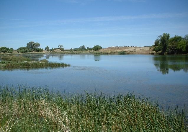
Near the towns of Sannieshof and Delareyville, the river is connected to Barberspan (26°35′ S 25°35′ E), which lies partially inside The Barbers Pan Nature Reserve and is a Ramsar wetland site. The pan is 11 km long and 3.5 km wide, and is named after Frederick Hugh Barber FRGS, who hunted along the Harts River in 1875 and not, as has been suggested, after the barbel (baber in the Afrikaans language), a species of catfish found in South African rivers. In 1913, Jan Christiaan Smuts, who owned a farm near the southern end of the pan, provided the labour and his foreman, Mr M.S. Basson, supervised the digging of a channel which diverted water from the Harts River into the pan, which lies about 9 m lower than the river. The area is so flat that the Harts River now pushes enough water into Barberspan during the rainy season to last through the dry winter months, where previously the pan used to dry up during the dry season. This was ecologically important, since the pan now became a large perennial water body in an area of otherwise seasonal pans and vleis. It became an oasis for birds (especially water fowl) which use it for feeding, drinking, roosting, molting and breeding. Up to 20,000 birds of more than 320 species can be seen at the Barbers Pan Bird Sanctuary, making it a popular birding spot, probably the finest in South Africa. Seven endangered bird species and two endangered mammal species occur here. Barberspan also supports a rich plankton community. (RAMSAR, 1994).
Near the confluence of the Harts and Vaal River a major irrigation system, the Vaal-Harts Scheme has been set up in 1933 as part of the national reconstruction effort after the Depression. Here water drawn from both the Vaal and the Harts rivers provide water to intensively irrigate numerous smallholdings through a system of canals in an otherwise dry area of the country, supporting towns such as Jankempdorp and Vaalharts.
Around the northern part of the Scheme lie the settlements of Pampierstad, Motsweding, Mokgareng, Manthestad and Taung, all with mostly Tswana speaking residents. Taung became famous after the discovery of the skull of the so-called Taung Child in a lime quarry 14km west of the town. To the west of the town, the Taung Dam was built in the Harts River.
On 31 March 1902, during the final months of the Second Boer War, the Battle of the Harts River, also known as Boschbult, was fought between the Boers and the British Forces near the confluence of the Harts River and the Brak Spruit, one of its dry tributaries.
Tributaries
| Name | Comment |
|---|---|
| Dry Harts River | |
| Little Harts River | |
| Great Harts River | |
| Kinkelspruit |
Geophysical
Topography
As a result of the low rainfall, flat topography and sandy soils over much of the area.
Geology
Mudstone, sandstone, tillite, quartzitic sand-stone, sand quartzite, and schist.
Basalt and biotite granite
Soils
Sandy soils
Sandy-clay-loam, sand-clay, sand-loam, clay-loam and loam-sand.
Hydrology and Geohydrology
Hydrology
Near the confluence of the Harts and Vaal River a major irrigation system, the Vaal-Harts Scheme has been set up in 1933 as part of the national reconstruction effort after the Depression. Here water drawn from both the Vaal and the Harts rivers provide water to intensively irrigate numerous smallholdings through a system of canals in an otherwise dry area of the country, supporting towns such as Jan Kempdorp and Vaalharts.
Water in the Harts River downstream of the Vaalharts irrigation scheme is of exceptional high salinity as a result of saline leachate from the irrigation fields (± 1 100 mg/l salinity), and needs to be carefully managed through blending with fresher water. Water quality in the lower reaches of the Vaal River is also impacted upon by irrigation return flows from the Harts River as well as from the Riet/Modder River further downstream, necessitating further blending with low salinity water from the Orange River at the Douglas weir.”
Ecology
Overview
Near the towns of Sannieshof and Delareyville, the river is connected to Barberspan (26°35′ S 25°35′ E), which lies partially inside The Barbers Pan Nature Reserve and is a Ramsar wetland site. The pan is 11 km long and 3.5 km wide, and is named after Frederick Hugh Barber FRGS, who hunted along the Harts River in 1875 and not, as has been suggested, after the barbel (baber in the Afrikaans language), a species of catfish found in South African rivers. In 1913, Jan Christiaan Smuts, who owned a farm near the southern end of the pan, provided the labour and his foreman, Mr M.S. Basson, supervised the digging of a channel which diverted water from the Harts River into the pan, which lies about 9 m lower than the river. The area is so flat that the Harts River now pushes enough water into Barberspan during the rainy season to last through the dry winter months, where previously the pan used to dry up during the dry season. This was ecologically important, since the pan now became a large perennial water body in an area of otherwise seasonal pans and vleis.
Aquatic Animals
Most of the fish found in the river are introduced species, except for Barberspan, which has indigenous species.
Terrestrial Animals
Barberspan became an oasis for birds (especially water fowl) which use it for feeding, drinking, roosting, moulting and breeding.Up to 20,000 birds of more than 320 species can be seen at the Barbers Pan Bird Sanctuary, making it a popular birding spot, probably the finest in South Africa. Seven endangered bird species and two endangered mammal species occur here. (RAMSAR, 1994)
Vegetation
The vegetation over the area is sparse, consisting mainly of grassland and some thorn trees, notably the majestic camel thorns.
Nama Karoo and Grasslands.
Climate
Temperature
Hot summer months and dry cool dry winters.
The annual average temperature range varies between 9°C (minimum) and 27°c (maximum).
Rainfall
Experience rainfall during the hot summer months.
Land-use
Agricultural
The Harts River plays an important role in the water supply to domestic and agricultural users in the area. Land use in the area is predominantly urban (both formal and informal) and agriculture (irrigated land as well as stock watering).
Land use is dominated by stock farming.
The main agricultural activities identified include livestock and dryland cropping. Livestock includes beef and dairy cattle, goats, non-wooled sheep, pigs and ostriches.
Crops grown are mainly maize, but also sunflower, cotton, groundnuts and vegetables.
Nature Conservation, Reserves and Tourism
- Barberspan Nature Reserve
- Barberspan Sanctuary
Industries
Lichtenburg is the largest manufacturing town in the area, where manufacturing includes cement and cheese factories.
Mining
Mining in the Taung (diamonds, limestone, dolomite and salt).
Populated Places
| Town | District | Municipality | River/Tributary |
|---|---|---|---|
| Delportshoop | Frances Baard | Dikgatlong | Confluence of the Harts and Vaal River |
| Hartswater | Frances Baard | Phokwane | Harts River |
| Jan Kempdorp | Frances Baard | Phokwane | Harts River |
| Lichtenburg | Central | Tswaing | Harts River |
| Manokwane | Bophirima | Greater Taung | Small tributary of the Harts River |
| Mokgareng | Bophirima | Greater Taung | Dry Harts River, tributary of the Harts River |
| Motsweding | Bophirima | Greater Taung | Harts River |
| Pampierstad | Frances Baard | Phokwane | Harts River |
| Schweizer-Reneke | Bophirima | Greater Taung | Small tributary of the Harts River |
| Taung | Bophirima | Greater Taung | Small tributary of the Harts River |
| Vaalharts | Frances Baard | Phokwane | Harts River |
| Vryburg | Bophirima | Greater Taung | Harts River |
Water Infrastructure
Dams
| Name | Capacity | Comments |
|---|---|---|
| Spitskop Dam | 58 | Construction completed in September 1994 |
| Taung Dam | 56 | |
| Wentzel Dam |
References:
The State of Rivers Report
Department of Water Affairs and Forestry, South Africa. 2004. Lower Vaal Water Management Area: Internal Strategic Perspective. Prepared by PDNA, WRP Consulting Engineers (Pty) Ltd, WMB and Kwezi-V3 on behalf of the Directorate: National Water Resource Planning. DWAF Report No P WMA 10/000/00/0304).
Wikipedia: Harts River